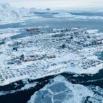
In the early hours of 6 June, on the 468th day of the war and anticipating the Ukrainian counter-offensive, Russian sappers from 205th Motor Rifle Brigade blew the Kakhovka Dam. The dam had 28 spans; 11 collapsed. 18 billion cubic metres of water was released in an engulfing and widening torrent. The act was reckless, spiteful and stupid. The picturesque Nova Kakhovka disappeared under ten metres of water, incidentally drowning all the animals in the zoo,which staff had valiantly kept alive through the war. Eighty settlements downstream were imperilled, and 29 flooded by the first day. Several left (east) bank settlements, including Oleshky, Korsunka, and Dnipryany, vanished underwater. The North Crimean Canal, on which the peninsula depends for water supply, lost its source. The Russians had made a great show of capturing this resource at the beginning of the war. Now they had destroyed it. For farmers in Kherson, Dnipropetrovsk, and Zaporizhzhia regions the destruction of the dam also spelt the loss of water supply to as many as three dozen irrigation systems. Only 13 irrigation systems had been operating on the Dnipro right bank. The demolition left 94 percent of irrigation systems in Kherson, 74 percent in Zaporizhia, and 30 percent in Dnipropetrovsk regions without a water source.
Much like the blowing of the Dniprovska Dam in 1941, Russian soldiers were not told the event was about to happen (more than 20,000 Red Army soldiers and civilians died following the destruction of the latter). At Nova Kakhovka, Ukrainians reported bemused and shocked Russian soldiers, as surprised as everybody else by the destruction of the dam. Five Russian soldiers had to be rescued by Ukrainian forces. Downstream defensive positions and minefields were washed away forcing Russian troops to withdraw 15 kilometres from the expanding Dnipro. A later released SBU intercept 1suggested the Russians had not intended to cause so much damage but bungled.
Ironically, one of the reasons why the Soviet authorities built the divisive Kakhovka Dam was to destroy it in case of war, and thus create an obstacle to an imagined enemy. Seventy years later, a malevolent Kremlin collected its insurance policy.
What existed before the construction of the Kakhovka Dam?
The Kakhovka Dam was constructed from 1950-56. The decision to build the dam was not without controversy. A consequence would be the flooding of roughly 2,155 square kilometres of the Zaporizhzhia Sich (‘Host’) and loss of 90 villages, churches and cemeteries. 40,000 people were displaced. Bronze Age Ukraine would also disappear under the water, a matter that did not especially trouble Stalin. These were the mythical lands for the famous Zaporizhzhia Cossacks (‘Zaporizhzhia’ means ‘lands beyond the rapids’; Herodotus knew of their existence in 5 BC). ‘The Sich [‘host’] is the mother, and the Veliky Lug [‘Great Meadow’] is the father,’ so the saying went. The area provided pasture for the semi-nomadic Cossacks and woodlands for sanctuary in the endless wars against the Tatars to the south for generations. The ancient oaks of this area provided the woods for the first Black Sea Fleet created by Potemkin.
Ukraine may be said to possess two national, spiritual loci. One is the capital. The other is the Zaporizhzhia Sich, where the autonomous Cossack Hetmanate existed in the 16th-18th centuries and later became a symbol of Ukrainian fighting spirit and independence. Stalin was keen to bury this too.
Before the building of the dam, the ‘Great Meadow’ was a floodplain. The geology of the rapids comprises 3 billion-year old granites, but the entire so-called ‘Ukrainian shield’ consists of ancient rock beds dating to the Archean and Quaternary period. The upper soils were extremely fertile and the land was rich in fauna and fish.
The floodplain stretched 110 kilometres from Khortytsya to Skalozubov in Kherson region. The width varied from 3 to 25 kilometres. The flood period typically started in April when the flood plains would become an almost continuous expanse of water. The maximum water level would be reached at the end of April and beginning of May, with the waters receding to a minimum by September-October. In some areas, the waters could rise to 7 metres.

The Dnipro River and flood plain of the Veliky Lug in 1894
Source: Photo Library and Information Centre Slovo Voennoye Obozreniye

The anger of inhabitants of the region forced to resettle was understandable. The six Dnipro dams were ultimately a typical Soviet project: vainglorious and contemptuous of the environments they destroyed. The six hydroelectric plants provided just 4% of Ukraine’s electricity. With the destruction of the Kakhovka Dam, another chapter was added to Russia’s abysmal environmental record.
Immediate and long-term consequences
More than two weeks after the destruction of the dam, the now-vanished reservoir presents a picture of a vast sandy expanse with hundreds of pools and rivulets slowly drying under the summer sun. The old course of the Dnipro has re-emerged. Almost 40 settlements, in the end, were flooded. Scores of civilians were drowned. The true number remains uncertain because the Russians will not allow UN disaster teams to visit the left bank.

Currently, the state of the land once submerged by the reservoir is constantly changing as the waters continue to recede and the bed dries. Russian reporter Voenkor Ilya Vasyunin (RT)2has visited the area. The implications of a dry bed have not escaped him. He writes:
‘Regarding the crossing of the Dnieper: in connection with the drainage of the Kakhovka reservoir, the front increased by about 200 km…Around June 12, Kyiv completely blocked the drain of water at the Dneproges Dam in Zaporozhye [the Dnipro Dam; the Ukrainian government stopped the water flow to mitigate the effects of the flood]. Now water does not enter the Dnieper at all. When it is completely dry, it will be possible to try to go in the direction of the Zaporozhye nuclear power plant [the ZNPP]. So far, the maximum this soil can withstand is a pickup truck. Tanks or infantry fighting vehicles will get bogged down. But for now, the weather is hot, with no rain. In the area of the village of Kamenskoye [Kam’yans’ke], where the LBS [frontline] passes, there is a possibility of bypassing our positions along the coastal line. This is now a headache for engineering and sapper troops.’
In short, Vasyunin reports the reservoir bed has dried enough to support light vehicles. At least in one area – at Kam’yans’ke, roughly 25 kilometres to the west of Orikhiv where fighting has been taking place recently – it is now possible to outflank the Russian defences by driving over the dried bed.
The interesting longer term question is: what will happen in the winter months? In winter the Dnipro freezes over, usually after a 20-day spell of sub-zero temperature. The average freezing and thawing dates are: Kyiv, 17 December-24 March; Cherkasy, 23 December-22 March; Zaporizhzhia, 5 January-9 March; and Kherson, 3 January-3 March. The freezing is not consistent: in some years the Dnipro freezes for short intervals, and in some years it does not freeze at all.

At the time of writing, there are no Russian troops or defensive positions along the entire length of what was the Kakhovka reservoir. The only significant presence is the Russian Guard (Rosgvardia) contingent at the Zaporizhzhia NPP. The absence of Russian troops extends further south almost to Nova Kakhovka. How will this almost 200 kilometre frontage be defended this winter if the Dnipro does indeed freeze over, and it becomes possible to simply drive across what was once the reservoir?
Sergio Miller
Sergio Miller is a retired British Army Intelligence Corps officer. He was a regular contributor and book reviewer forBritish Army Review. He is the author of a two-part history of the Vietnam War (Osprey/Bloomsbury) and is currently drafting a history of the Russian invasion of Ukraine.
- Sergio Miller
- Sergio Miller

- Sergio Miller
- Sergio Miller